Back Ċeasterfeld ANG تشيسترفيلد (ديربيشاير) Arabic چسترفیلد AZB Чэстэрфілд (Англія) BE Честърфийлд Bulgarian Chesterfield (Bro-Saoz) BR Chesterfield Catalan Chesterfield (lungsod sa Hiniusang Gingharian) CEB Chesterfield Czech Chesterfield CY
| Niet-metropolitaans district in Engeland | |||
|---|---|---|---|
 
| |||
| Situering | |||
| Land | Engeland | ||
| County | Derbyshire | ||
| Regio | East Midlands | ||
| Coördinaten | 53°14'9"NB, 1°25'39"WL | ||
| Algemeen | |||
| Oppervlakte | 66,0352[1] km² | ||
| Inwoners (2018[2]) |
104.628 (1584 inw./km²) | ||
| ONS-code | E07000034 | ||
| Website | Officiële website | ||
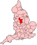
| Detailkaart | |||

| |||
| Foto's | |||

| |||
| De kromme gedraaide kerktoren van Chesterfield | |||
| |||
Chesterfield is een marktplaats en een lokaal district in het shire-graafschap (non-metropolitan county OF county) Derbyshire. Het ligt ten zuiden van Sheffield waar de rivieren Rother en Hipper samenvloeien en heeft een inwoneraantal van ongeveer 105.000. De locatie is 53°34′N 1°25′W. Een andere plaats in district Chesterfield is Staveley.
- ↑ Office for National Statistics → Download → SAM_for_Administrative_Areas_(2018).zip → SAM_LAD_DEC_2018_UK.xlsx. Gearchiveerd op 7 april 2023.
- ↑ https://www.ons.gov.uk/file?uri=/peoplepopulationandcommunity/populationandmigration/populationestimates/datasets/populationestimatesforukenglandandwalesscotlandandnorthernireland/mid20182019laboundaries/ukmidyearestimates20182019ladcodes.xls Schatting Office for National Statistics: knop MYE5 → kolom Estimated Population mid-2018]