Back Frederick Douglass National Historic Site CEB Site historique national Frederick Douglass French فریڈرک ڈگلس نیشنل ہسٹورک سائٹ UR
| Frederick Douglass National Historic Site | |
|---|---|
 | |
| Location | Washington, D.C., U.S. |
| Nearest city | Washington, D.C. |
| Coordinates | 38°51′48″N 76°59′07″W / 38.86333°N 76.98528°W |
| Area | 9 acres (3.6 ha) |
| Established | February 12, 1988 |
| Visitors | 23,226 (in 2005) |
| Governing body | National Park Service |
| Website | Frederick Douglass National Historic Site |
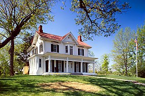
The Frederick Douglass National Historic Site, administered by the National Park Service, is located at 1411 W Street, SE, in Anacostia, a neighborhood east of the Anacostia River in Southeast Washington, D.C. United States. Established in 1988 as a National Historic Site, the site preserves the home and estate of Frederick Douglass, one of the most prominent African Americans of the 19th century. Douglass lived in this house, which he named Cedar Hill, from 1877–1878 until his death in 1895. Perched on a hilltop, the site offers a sweeping view of the U.S. Capitol and the Washington, D.C., skyline.
In 2017 the site was used to represent Washington, D.C., on its America the Beautiful quarter.


