Back أنغوس Arabic Ангус BE Ангъс Bulgarian Aonghas BR Angus Catalan Ангус (регион) CE Angus (dapit sa konseho) CEB Angus Czech Angus CY Angus Danish
Angus
Aonghas (Scottish Gaelic) | |
|---|---|
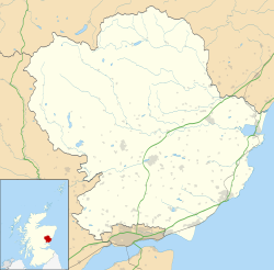
 Angus shown within Scotland | |
| Coordinates: 56°40′N 2°55′W / 56.667°N 2.917°W | |
| Sovereign state | United Kingdom |
| Country | Scotland |
| Lieutenancy area | Angus |
| Unitary authority | 1 April 1996 |
| Administrative HQ | Forfar Town and County Hall |
| Government | |
| • Type | Council |
| • Body | Angus Council |
| • Control | No overall control |
| • MPs | 2 MPs |
| • MSPs | 2 MSPs |
| Area | |
| • Total | 842 sq mi (2,181 km2) |
| • Rank | 10th |
| Population (2022)[2] | |
| • Total | 114,660 |
| • Rank | 18th |
| • Density | 140/sq mi (53/km2) |
| Time zone | UTC+0 (GMT) |
| • Summer (DST) | UTC+1 (BST) |
| ISO 3166 code | GB-ANS |
| GSS code | S12000041 |
| Website | angus |
Angus (Scots: Angus; Scottish Gaelic: Aonghas) is one of the 32 local government council areas of Scotland, and a lieutenancy area. The council area borders Aberdeenshire, Dundee City and Perth and Kinross. Main industries include agriculture and fishing. Global pharmaceuticals company GSK has a significant presence in Montrose in the east of the county.
Angus was historically a province, and later a sheriffdom and county (called Forfarshire or the County of Forfar until 1928), bordering Kincardineshire to the north-east, Aberdeenshire to the north and Perthshire to the west; southwards it faced Fife across the Firth of Tay. The county included Dundee until 1894, when it was made a county of a city. The pre-1894 boundaries of Angus continue to be used as a registration county. Between 1975 and 1996 Angus was a lower-tier district within the Tayside region. The district took on its modern form and powers in 1996, since when the local authority has been Angus Council.
- ^ "Council, committees and elections". Angus Council. Retrieved 7 September 2024.
- ^ a b "Mid-Year Population Estimates, UK, June 2022". Office for National Statistics. 26 March 2024. Retrieved 3 May 2024.

