Our website is made possible by displaying online advertisements to our visitors.
Please consider supporting us by disabling your ad blocker.

Louisville, Kentucky
Louisville, Kentucky | |
|---|---|
| Louisville/Jefferson County Metro Government | |
 From top: Louisville downtown skyline at night, Cathedral of the Assumption, Thunder Over Louisville fireworks during the Kentucky Derby Festival, Kentucky Derby, Louisville Slugger Museum & Factory, Fourth Street Live!, The Kentucky Center for the Performing Arts | |
| Nickname(s): | |
![highlighted portion of Jefferson County represents the "balance" population of Louisville [source?] Also seen is the location of Louisville in the state of Kentucky.](view.php?q=Louisville,_Kentucky&sq=PHP&lang=simple&file=File:Jefferson_County_Kentucky_Incorporated_and_Unincorporated_areas_Louisville-Jefferson_County_metro_government_(balance)_Highlighted_2148006.svg) highlighted portion of Jefferson County represents the "balance" population of Louisville [source?] Also seen is the location of Louisville in the state of Kentucky. | |
 Louisville Location within Kentucky  Louisville Location within the United States  Louisville Location within North America | |
| Coordinates: 38°15′22″N 85°45′05″W / 38.25611°N 85.75139°W | |
| Country | United States |
| State | Kentucky |
| County | Jefferson |
| Founded by | George Rogers Clark |
| Named for | Louis XVI |
| Government | |
| • Type | Mayor–council |
| • Mayor | Craig Greenberg (D) |
| • Metro Council | 26 council members |
| Area | |
| • Consolidated city-county | 397.68 sq mi (1,030 km2) |
| • Land | 380.46 sq mi (985.4 km2) |
| • Water | 17.23 sq mi (44.6 km2) |
| Elevation | 466 ft (142 m) |
| Population (2020) | |
| • Consolidated city-county | 782,969[4] (consolidated) 633,045[5] (balance) |
| • Rank | 29th in the United States 1st in Kentucky |
| • Density | 1,663.89/sq mi (642.42/km2) |
| • Metro | 1,285,439 (45th) |
| Demonym | Louisvillian[7] |
| Time zone | UTC-5 (EST) |
| • Summer (DST) | UTC-4 (EDT) |
| ZIP code prefixes | major: 402xx minor: 400xx, 401xx |
| Area code | 502 |
| FIPS code | 21-48006 |
| GNIS feature ID | 0509453[8] |
| USDA hardiness zones | 6b, 7a |
| Interstates | |
| Airports | Louisville International Airport, Bowman Field |
| Waterways | Ohio River, Beargrass Creek, Floyds Fork, Harrods Creek |
| Website | LouisvilleKy.gov |
Louisville is the largest city in the state of Kentucky in the USA. The settlement that became the City of Louisville was founded in 1778 by George Rogers Clark. It is named after King Louis XVI of France. It was an important river port in the 19th century. Many people come to the city in May for the Kentucky Derby horse race.
Here are some pictures of buildings in Louisville:
-
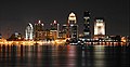 The middle of Louisville at night
 -
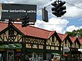 East Louisville's Highlands area
 -
 Louisville City Hall (city government offices)
 -
 A giant baseball bat decorates the outside of Louisville Slugger Museum & Factory.
 -
 The Belle of Louisville is a very old steamboat


- ↑ "Transit Authority of River City (TARC)". ridetarc.org. Retrieved June 11, 2016.
- ↑ * "The Gateway to the South: A Beginner's Guide to Louisville". The Virgin Atlantic Blog. January 2014. Archived from the original on September 11, 2015. Retrieved August 10, 2015.
- K'Meyer, Tracy E. (January 1, 2010). Civil Rights in the Gateway to the South: Louisville, Kentucky, 1945–1980. Lexington, Kentucky: University Press of Kentucky. ISBN 978-0813139203. Retrieved August 10, 2015.
- "Flooded riverfront, Louisville, Kentucky, 1937. :: R. G. Potter Collection". Archived from the original on September 29, 2015. Retrieved August 10, 2015.
View of downtown Louisville, Kentucky, with buildings submerged by floodwater. Neon sign on top of building reads: "The Gateway to the South Louisville Gas & Electric Co."
- ↑
- Puckett, Jeffrey Lee (March 9, 2016). "The Who, other must-see shows in the 'Ville". The Courier-Journal. Retrieved June 11, 2016.
- Forde, Pat (September 10, 2003). "UofL's bogus billboards don't impress experts". The Courier-Journal.
- ↑ "QuickFacts: Jefferson County, Kentucky". United States Census Bureau. Retrieved 22 August 2021.
- ↑ "QuickFacts: Louisville city, Kentucky; Louisville/Jefferson County metro government (balance), Kentucky". United States Census Bureau. Retrieved 22 August 2021.
- ↑ "2020 Population and Housing State Data". United States Census Bureau. Retrieved 22 August 2021.
- ↑ "Definition of Louisvillian". Merriam-Webster Dictionary. Retrieved November 5, 2020.
- ↑ "GNIS Detail—Louisville". Archived from the original on August 3, 2020. Retrieved June 23, 2014.
- ↑ Commonwealth of Kentucky. Office of the Secretary of State. Land Office. "Louisville, Kentucky". Accessed September 19, 2013.
Previous Page Next Page

