Our website is made possible by displaying online advertisements to our visitors.
Please consider supporting us by disabling your ad blocker.
Logan, Ohio
Logan, Ohio | |
|---|---|
 West Main Street in downtown Logan in 2006 | |
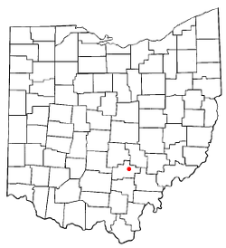
 Location of Logan, Ohio | |
 Detailed map of Logan | |
| Coordinates: 39°32′04″N 82°23′26″W / 39.53444°N 82.39056°W | |
| Country | United States |
| State | Ohio |
| County | Hocking |
| Area | |
| • Total | 4.93 sq mi (12.77 km2) |
| • Land | 4.79 sq mi (12.41 km2) |
| • Water | 0.14 sq mi (0.36 km2) |
| Elevation | 742 ft (226 m) |
| Population | |
| • Total | 7,296 |
| • Density | 1,522.86/sq mi (587.96/km2) |
| Time zone | UTC-5 (Eastern (EST)) |
| • Summer (DST) | UTC-4 (EDT) |
| ZIP code | 43138 |
| Area code | 740 |
| FIPS code | 39-44632[4] |
| GNIS feature ID | 2395743[2] |
| Website | Official website |
Logan is a city in the U.S. state of Ohio. It is the county seat of Hocking County.[5] 7,296 people lived there in the 2020 census.[3] The city is in southeast Ohio, on the Hocking River 48 miles southeast of Columbus.
The current mayor of Logan is Republican Greg Fraunfelter, who began a four-year term in January 2016.[6]
- ↑ "ArcGIS REST Services Directory". United States Census Bureau. Retrieved September 20, 2022.
- ↑ 2.0 2.1 U.S. Geological Survey Geographic Names Information System: Logan, Ohio
- ↑ 3.0 3.1 "QuickFacts: Logan city, Ohio". United States Census Bureau. Retrieved March 15, 2024.
- ↑ "U.S. Census website". United States Census Bureau. Retrieved 2008-01-31.
- ↑ "Find a County". National Association of Counties. Retrieved 2011-06-07.
- ↑ Tobin, Debra. "Fraunfelter elected as Logan City Mayor". Logan Daily News. Retrieved 2016-06-03.
Previous Page Next Page


