Our website is made possible by displaying online advertisements to our visitors.
Please consider supporting us by disabling your ad blocker.
Harrison County, Missouri
Harrison County | |
|---|---|
 Harrison County Courthouse in Bethany | |
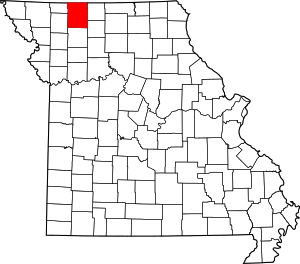
 Location within the U.S. state of Missouri | |
 Missouri's location within the U.S. | |
| Coordinates: 40°21′N 93°59′W / 40.35°N 93.98°W | |
| Country | |
| State | |
| Founded | February 14, 1845 |
| Named for | Albert G. Harrison |
| Seat | Bethany |
| Largest city | Bethany |
| Area | |
| • Total | 726 sq mi (1,880 km2) |
| • Land | 723 sq mi (1,870 km2) |
| • Water | 3.9 sq mi (10 km2) 0.5% |
| Population | |
| • Total | 8,157 |
| • Density | 11/sq mi (4.3/km2) |
| Time zone | UTC−6 (Central) |
| • Summer (DST) | UTC−5 (CDT) |
Harrison County is a county in Missouri, United States. The county seat is Bethany.[2] In 2020, 8,157 people lived there.[1] The county was organized on February 14, 1845 and named for U.S. Representative Albert G. Harrison of Missouri.[3]
- ↑ 1.0 1.1 "QuickFacts: Harrison County, Missouri". United States Census Bureau. Retrieved August 11, 2023.
- ↑ "Find a County". National Association of Counties. Retrieved 2011-06-07.
- ↑ Eaton, David Wolfe (1916). How Missouri Counties, Towns and Streams Were Named. The State Historical Society of Missouri. p. 171.
Previous Page Next Page
مقاطعة هاريسون (ميزوري) Arabic هریسون بؤلگهسی، میزوری AZB Harrison County, Missouri BAR Харисън (окръг, Мисури) Bulgarian হারিসওন কাউন্টি, মিসৌরি BPY Harrison Gông (Missouri) CDO Харрисон (гуо, Миссури) CE Harrison County (kondado sa Tinipong Bansa, Missouri) CEB Harrison County, Missouri CY Harrison County (Missouri) German


