Our website is made possible by displaying online advertisements to our visitors.
Please consider supporting us by disabling your ad blocker.
Kergelenoj

| Kergelenoj | |||||
|---|---|---|---|---|---|
 | |||||
| Supermara alteco | 409 m [+] | ||||
| Koordinatoj | 49° 15′ S, 69° 10′ O (mapo)-49.2569.166666666667Koordinatoj: 49° 15′ S, 69° 10′ O (mapo) [+] | ||||
| Plej alta punkto | Mont Ross | ||||
| - alteco | 1 850 m | ||||
| Akvokolektejo | 7 215 km² (721 500 ha) [+] | ||||
| Areo | 7 215 km² (721 500 ha) [+] | ||||
| Loĝantaro | 60 , en somero 120 | ||||
| Horzono | UTC+05:00 [+] | ||||
| Plej granda fjordo | Baie de Recques (21 km) | ||||
| Plej granda lago | Lac Marville (25 km²) | ||||
| Plej granda insulo | Île Kerguelen / Grande Terre (6675 km²) | ||||
| Plej granda glaĉero | Glaĉero Cook (Kergelenoj) / Calotte Glaciaire Cook (403 km²) | ||||
 |
|||||
| Kergelenoj | |||||


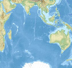
Kergelenoj [1] ( france/angle : Kerguelen) estas insularo en la Hinda oceano, apartenanta al la Francaj Sudaj kaj Antarktaj Teritorioj.
- ↑ Plena Ilustrita Vortaro 2002 p.549
Previous Page Next Page


