Our website is made possible by displaying online advertisements to our visitors.
Please consider supporting us by disabling your ad blocker.
Yellow River (Indiana)
| Yellow River | |
|---|---|
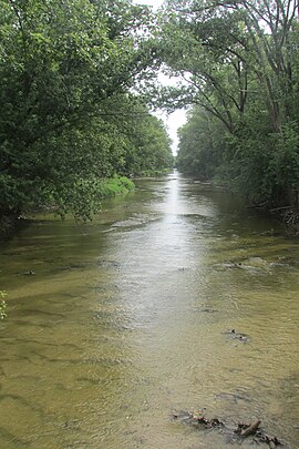
 The Yellow River got its name from the sandy bottom. | |
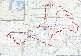
 Yellow River watershed (Interactive map) | |
| Location | |
| Country | United States |
| State | Indiana |
| Physical characteristics | |
| Source | |
| • location | St. Joseph County |
| • coordinates | 41°29′54″N 86°09′08″W / 41.49833°N 86.15222°W[1] |
| • elevation | 804 ft (245 m)[2] |
| Mouth | Kankakee River |
• location | Starke County |
• coordinates | 41°16′16″N 86°49′35″W / 41.27111°N 86.82639°W[1] |
• elevation | 656 ft (200 m)[2] |
| Length | 62 mi (100 km)approx.[3] |
| Basin size | 427 sq mi (1,110 km2)[4] |
| Discharge | |
| • location | mouth |
| • average | 493.35 cu ft/s (13.970 m3/s) (estimate)[5] |

The Yellow River is a 62.3-mile-long (100.3 km)[6] tributary of the Kankakee River in the Central Corn Belt Plains ecoregion, located in northern Indiana in the United States. Via the Kankakee and Illinois rivers, it is part of the watershed of the Mississippi River, draining an area of 427 square miles (1,110 km2).
The river's name is recorded in the Miami-Illinois language as oonsasiipi ("yellow river") and oonsaalamoonakami(i)ki ("it is yellow ocher water"), and in Potawatomi as wezawgəməg ("at the yellow water"), reflecting the river's original yellowish-brown muddy color.[7]
- ^ a b Geographic Names Information System. "Geographic Names Information System entry for Yellow River (Feature ID #452845)". Retrieved 2007-04-23.
- ^ a b Google Earth elevation for GNIS source coordinates. Retrieved on 2007-04-23.
- ^ "Yellow River". Columbia Gazetteer of North America. Columbia University Press. 2000. Retrieved 2007-04-23.
- ^ Price, Jeremy; Bob Robertson (January 2005). "Fishery, Habitat, and Recreational Use Surveys For the Kankakee River, Indiana" (PDF). Fisheries Division. Indiana Department of Natural Resources, Division of Fish and Wildlife. Retrieved 2007-04-23.
- ^ United States Environmental Protection Agency. "Watershed Report: Yellow River". watersgeo.epa.gov. Archived from the original on 2021-07-05. Retrieved 2021-07-05.
- ^ U.S. Geological Survey. National Hydrography Dataset high-resolution flowline data. The National Map, accessed May 13, 2011
- ^ McCafferty, Michael (2008). Native American Place-Names of Indiana. University of Illinois Press. pp. 63–64. ISBN 9780252032684.
Previous Page Next Page


