Our website is made possible by displaying online advertisements to our visitors.
Please consider supporting us by disabling your ad blocker.
Ter Apel
This article needs additional citations for verification. (April 2015) |
Ter Apel | |
|---|---|
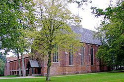
 Ter Apel Monastery in 2008 | |
Location in the province of Groningen in the Netherlands | |
| Coordinates: 52°52′32″N 7°3′35″E / 52.87556°N 7.05972°E | |
| Country | Netherlands |
| Province | Groningen |
| Municipality | Westerwolde |
| Area | |
| • Total | 0.8191 km2 (0.3163 sq mi) |
| Population | |
| • Total | 9,914 |
| • Density | 12,000/km2 (31,000/sq mi) |
| Time zone | UTC+1 (CET) |
| • Summer (DST) | UTC+2 (CEST) |
| Postal code | 9561 |
Ter Apel (Dutch pronunciation: [tɛr ˈaːpəl]; Gronings: Troapel) is a village[citation needed] with a population of 9,914 residents[citation needed] in the municipality Westerwolde in the northern Netherlands, in the province Groningen in the region Westerwolde.[1] The town lies on the stream Ruiten Aa, which has the valley that together with the Ter Apeler forest belongs to the national network of nature reserves, the Ecologische Hoofdstructuur. An accommodation centre for refugees is located at Ter Apel, functioning as a "departure centre" for rejected refugees and a registration point, operated by the Centraal Orgaan opvang Asielzoekers. Ter Apel lies on the roads N366, N976 and N391. It forms the southern point of the border between Groningen and Drenthe, the Semslinie.
Previous Page Next Page


