Our website is made possible by displaying online advertisements to our visitors.
Please consider supporting us by disabling your ad blocker.
Sydney Road
Sydney Road Hume Highway | |
|---|---|
 | |
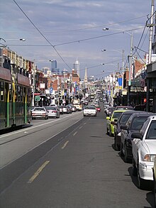
| Sydney Road, Brunswick, looking south to the CBD | |
| General information | |
| Type | Road |
| Length | 24 km (15 mi)[1] |
| Route number(s) |
|
| Former route number |
|
| Major junctions | |
| North end | Craigieburn, Melbourne |
| South end | Brunswick, Melbourne |
| Location(s) | |
| LGA(s) | |
| Major suburbs | Craigieburn, Somerton, Campbellfield, Coburg |
| ---- | |

Sydney Road (in its northernmost part also known as the Hume Highway) is a major urban arterial in the northern suburbs of Melbourne, Victoria, Australia.
- ^ "Sydney Road" (Map). Google Maps. Retrieved 19 October 2021.
Previous Page Next Page


