Our website is made possible by displaying online advertisements to our visitors.
Please consider supporting us by disabling your ad blocker.
Shaker Heights, Ohio
Shaker Heights, Ohio | |
|---|---|
 | |
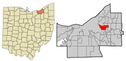
 Location in Cuyahoga County and the state of Ohio. | |
| Coordinates: 41°28′35″N 81°33′6″W / 41.47639°N 81.55167°W | |
| Country | United States |
| State | Ohio |
| County | Cuyahoga |
| Established | 1911 |
| Incorporated | 1912 |
| Government | |
| • Mayor | David Weiss (D) |
| Area | |
| • Total | 6.33 sq mi (16.40 km2) |
| • Land | 6.29 sq mi (16.29 km2) |
| • Water | 0.04 sq mi (0.11 km2) |
| Elevation | 1,050 ft (320 m) |
| Population (2020) | |
| • Total | 29,439 |
| • Density | 4,679.54/sq mi (1,806.68/km2) |
| Time zone | UTC-5 (Eastern (EST)) |
| • Summer (DST) | UTC-4 (EDT) |
| ZIP codes | 44118, 44120, 44122 |
| Area code | 216 |
| FIPS code | 39-71682[3] |
| GNIS feature ID | 1065308[2] |
| Website | www.shakeronline.com |
Shaker Heights is a city in Cuyahoga County, Ohio, United States. As of the 2020 census, the city's population was 29,439. Shaker Heights is an inner-ring streetcar suburb of Cleveland, abutting the eastern edge of the city's limits. It is a planned community developed by the Van Sweringen brothers, railroad moguls who envisioned the community as a suburban retreat from the industrial inner city of Cleveland.
- ^ "ArcGIS REST Services Directory". United States Census Bureau. Retrieved September 20, 2022.
- ^ a b U.S. Geological Survey Geographic Names Information System: Shaker Heights, Ohio
- ^ "U.S. Census website". United States Census Bureau. Retrieved January 31, 2008.
Previous Page Next Page


