Our website is made possible by displaying online advertisements to our visitors.
Please consider supporting us by disabling your ad blocker.
Rockbridge, Ohio
Rockbridge, Ohio | |
|---|---|
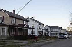
 Houses on Jackson Street south of the post office | |
 Location of Rockbridge, Ohio | |
| Coordinates: 39°35′10″N 82°31′34″W / 39.58611°N 82.52611°W | |
| Country | United States |
| State | Ohio |
| County | Hocking |
| Township | Good Hope |
| Area | |
| • Total | 0.38 sq mi (0.98 km2) |
| • Land | 0.38 sq mi (0.98 km2) |
| • Water | 0.00 sq mi (0.00 km2) |
| Elevation | 846 ft (258 m) |
| Population (2020) | |
| • Total | 160 |
| • Density | 423.28/sq mi (163.55/km2) |
| Time zone | UTC-5 (Eastern (EST)) |
| • Summer (DST) | UTC-4 (EDT) |
| ZIP code | 43149 |
| Area code | 740 |
| FIPS code | 39-67804 |
| GNIS feature ID | 2628962[2] |
Rockbridge is an unincorporated community and census-designated place (CDP) in eastern Good Hope Township, Hocking County, Ohio, United States. It has a post office with the ZIP code 43149.[3] It is located at the interchange of U.S. Route 33 and State Route 374, between Logan and Lancaster. As of the 2020 census the population of the CDP was 160.
- ^ "ArcGIS REST Services Directory". United States Census Bureau. Retrieved September 20, 2022.
- ^ a b U.S. Geological Survey Geographic Names Information System: Rockbridge, Ohio
- ^ USPS Zip Code Lookup
Previous Page Next Page


