Our website is made possible by displaying online advertisements to our visitors.
Please consider supporting us by disabling your ad blocker.
Rif
| Rif | |
|---|---|
 A view of the Rif mountains around Chefchaouen | |
| Highest point | |
| Peak | Jbel Tidirhine |
| Elevation | 2,455 m (8,054 ft) |
| Naming | |
| Native name | |
| Geography | |
| Country | Morocco |
| Range coordinates | 35°N 4°W / 35°N 4°W |
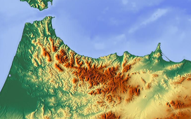
The Rif or Riff (Tarifit: ⴰⵔⵔⵉⴼ, ⴰⵔⵉⴼ, romanized: Arrif, Arif, Arabic: الريف), also called Rif Mountains, is a geographic region in northern Morocco. It is bordered on the north by the Mediterranean Sea and Spain and on the west by the Atlantic Ocean, and is the homeland of the Rifians and the Jebala people. This mountainous and fertile area is bordered by Cape Spartel and Tangier to the west, by Berkane and the Moulouya River to the east, by the Mediterranean to the north, and by the Ouergha River to the south. The Rif mountains are separated into the eastern Rif mountains (Nador, Driouch, Al Hoceima) and western Rif mountains (Tangier, Tetouan, Chefchaouen, Taounate).[1]
- ^ "Rif | mountains, Morocco | Britannica". www.britannica.com. Retrieved 2022-05-31.
Previous Page Next Page


