Our website is made possible by displaying online advertisements to our visitors.
Please consider supporting us by disabling your ad blocker.
Ningi, Nigeria
This article needs additional citations for verification. (September 2023) |
Ningi, Nigeria | |
|---|---|
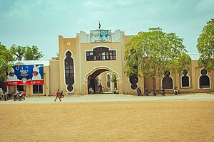
 Ningi Emirate Palace | |
| Coordinates: 11°4′N 9°34′E / 11.067°N 9.567°E | |
| Country | |
| State | Bauchi State |
 | |
Ningi is a town, a local government area, and an emirate in Bauchi State, Nigeria. The Ningi emirate comprises two local government areas, Ningi and Warji, with a combined area of 5,250 km2 and a population of 501,912 according to the 2006 Census. The Ningi local government area covers an area of 4,625 km2 with a population of 387,192 at the 2006 Census. The area is inhabited mostly by hausa people, Duwa, Ningawa. Yunusa Muhammadu Danyaya was the longes Emir to reigned who ascended the throne from 1978 until his death on 25 August 2024.
Previous Page Next Page


