Our website is made possible by displaying online advertisements to our visitors.
Please consider supporting us by disabling your ad blocker.
Nantua
You can help expand this article with text translated from the corresponding article in French. (December 2008) Click [show] for important translation instructions.
|
Nantua
Nantuat (Arpitan) | |
|---|---|
Subprefecture and commune | |
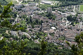
 A view of Nantua | |
| Coordinates: 46°09′07″N 5°36′28″E / 46.1519°N 5.6078°E | |
| Country | France |
| Region | Auvergne-Rhône-Alpes |
| Department | Ain |
| Arrondissement | Nantua |
| Canton | Nantua |
| Intercommunality | Haut-Bugey Agglomération |
| Government | |
| • Mayor (2020–2026) | Jean-Pascal Thomasset[1] (DVD) |
| Area 1 | 12.79 km2 (4.94 sq mi) |
| Population (2021)[2] | 3,449 |
| • Density | 270/km2 (700/sq mi) |
| Time zone | UTC+01:00 (CET) |
| • Summer (DST) | UTC+02:00 (CEST) |
| INSEE/Postal code | 01269 /01130 |
| Elevation | 479 m (1,572 ft) |
| 1 French Land Register data, which excludes lakes, ponds, glaciers > 1 km2 (0.386 sq mi or 247 acres) and river estuaries. | |

Nantua (French pronunciation: [nɑ̃tɥa] ; Arpitan: Nantuat) is a commune in and subprefecture of the Ain département in the Auvergne-Rhône-Alpes region in Eastern France. The commune of Nantua comprises the glacial Lac de Nantua.
Located in the Haut-Bugey historical region, among the southern foothills of the Jura Mountains, it is famous for its fresh-water fish and crayfish.[3]
- ^ "Répertoire national des élus: les maires" (in French). data.gouv.fr, Plateforme ouverte des données publiques françaises. 13 September 2022. Archived from the original on 28 June 2020. Retrieved 22 November 2022.
- ^ "Populations légales 2021" (in French). The National Institute of Statistics and Economic Studies. 28 December 2023.
- ^ Waverley Root, The Food of France, p. 215
Previous Page Next Page


