Our website is made possible by displaying online advertisements to our visitors.
Please consider supporting us by disabling your ad blocker.
Marquesas Keys
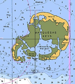
 NOAA Nautical chart of the Marquesas Keys: part of Chart No. 11439 "Sand Key to Rebecca Shoal" | |
 | |
| Geography | |
|---|---|
| Location | Caribbean |
| Coordinates | 24°34′19″N 82°07′10″W / 24.57194°N 82.11944°W |
| Archipelago | Florida Keys |
| Total islands | 9 |
| Major islands | Entrance Key |
| Area | 6.58 km2 (2.54 sq mi) |
| Administration | |
United States | |
| State | Florida |
| County | Monroe County, Florida |
| Census County Division | Lower Keys |
The Marquesas Keys form an uninhabited island group about 20 miles (32 km) west of Key West, four miles (6 km) in diameter, and largely covered by mangrove forest. They are an unincorporated area of Monroe County, Florida and belong to the Lower Keys Census County Division.[1] They are protected as part of the Key West National Wildlife Refuge.[2] The Marquesas were used for target practice by the military as recently as 1980.

Previous Page Next Page


