Our website is made possible by displaying online advertisements to our visitors.
Please consider supporting us by disabling your ad blocker.
Mallee (region, Victoria)
| Mallee Victoria | |||||||||||||||
|---|---|---|---|---|---|---|---|---|---|---|---|---|---|---|---|
 | |||||||||||||||
| Population | 88,178 (2011 census)[note 1] | ||||||||||||||
| • Density | 2.19441/km2 (5.68350/sq mi) | ||||||||||||||
| Area | 40,183 km2 (15,514.7 sq mi)[note 2][1][failed verification] | ||||||||||||||
| LGA(s) | |||||||||||||||
| Region | Loddon Mallee | ||||||||||||||
| State electorate(s) | |||||||||||||||
| Federal division(s) | Mallee | ||||||||||||||
| |||||||||||||||
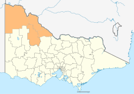
The Mallee is a sub-region of Loddon Mallee covering the most north-westerly part of Victoria, Australia and is bounded by the South Australian and New South Wales borders. Definitions of the south-eastern boundary vary, however, all are based on the historic Victorian distribution of mallee eucalypts. These trees dominate the surviving native vegetation through most of Mallee, (except for swamps and areas along waterways). Its biggest settlements are Mildura and Swan Hill.
At the 2011 census, the four local government areas (LGAs) that are usually thought to define the district had a combined population of 88,178. The area of these same four LGAs is 40,183 square kilometres (15,515 sq mi).

An area of South Australia immediately to the west of the Victorian Mallee region, also once covered with mallee scrub, is commonly referred to as the "Murray Mallee" or "the Mallee".
Cite error: There are <ref group=note> tags on this page, but the references will not show without a {{reflist|group=note}} template (see the help page).
- ^ "The Mallee region". Department of Environment and Primary Industries. Government of Victoria. 30 January 2014. Retrieved 15 August 2014.
Previous Page Next Page


