Our website is made possible by displaying online advertisements to our visitors.
Please consider supporting us by disabling your ad blocker.
Lagos Island
Lagos Island
Ìsàlẹ̀ Èkó | |
|---|---|
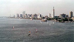
 Lagos Island skyline | |
| Nickname: Lasgidi | |
 Lagos Island shown within Lagos | |
Lagos Island shown within Nigeria | |
| Coordinates: 6°27′N 3°24′E / 6.450°N 3.400°E | |
| Country | |
| State | Lagos State |
| City | Lagos |
| Area | |
| • Total | 3.58 sq mi (9.26 km2) |
| Population (2022)[1] | |
| • Total | 314,900 |
| • Density | 88,000/sq mi (34,000/km2) |
| Time zone | UTC+1 (WAT) |
| postal code | 101001 |
 | |
Lagos Island (Yoruba: Ìsàlẹ̀ Èkó) is the principal and central Local Government Area (LGA) in Lagos, Nigeria. It was the capital of Lagos State until 1957.[2] It is part of the Lagos Division.[3] As of the preliminary 2006 Nigerian census, the LGA had a population of 209,437 within an area of just 8.7 km2. The LGA only covers the western half of Lagos Island; the eastern half is simply referred to as Lagos Island East LCDA.
- ^ "Lagos State: Subdivisions". City Population. Retrieved 5 February 2024.
- ^ "Lagos | City, Population, & History". Encyclopædia Britannica. Archived from the original on 5 June 2019. Retrieved 19 July 2022.
- ^ "List of Local Governments in Lagos State". Nigerian Finder. 26 October 2020. Archived from the original on 27 September 2021. Retrieved 22 June 2022.
Previous Page Next Page


