Our website is made possible by displaying online advertisements to our visitors.
Please consider supporting us by disabling your ad blocker.
Islip, Oxfordshire
| Islip | |
|---|---|
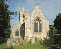
 St Nicholas the Confessor parish church | |
Location within Oxfordshire | |
| Area | 6.42 km2 (2.48 sq mi) |
| Population | 652 (2011 Census) |
| • Density | 102/km2 (260/sq mi) |
| OS grid reference | SP5214 |
| Civil parish |
|
| District | |
| Shire county | |
| Region | |
| Country | England |
| Sovereign state | United Kingdom |
| Post town | KIDLINGTON |
| Postcode district | OX5 |
| Dialling code | 01865 |
| Police | Thames Valley |
| Fire | Oxfordshire |
| Ambulance | South Central |
| UK Parliament | |
Islip (/ˈaɪslɪp/) is a village and civil parish on the River Ray, just above its confluence with the River Cherwell in Oxfordshire, England. It is about 2 miles (3 km) east of Kidlington and about 5 miles (8 km) north of Oxford. The 2011 Census recorded the parish's population as 652.[1]
- ^ "Islip Parish". nomis. Durham University for Office for National Statistics. Retrieved 4 January 2021.
Previous Page Next Page


