Our website is made possible by displaying online advertisements to our visitors.
Please consider supporting us by disabling your ad blocker.
Interstate 485 (Georgia)
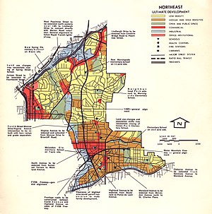
 1970 map of the proposed route of I-485 through northeast Atlanta | ||||
| Route information | ||||
| Auxiliary route of I-85 | ||||
| Length | 5.9 mi[1] (9.5 km) | |||
| Existed | 1964[citation needed]–1975[2] | |||
| NHS | Entire route | |||
| Location | ||||
| Country | United States | |||
| State | Georgia | |||
| Counties | Fulton | |||
| Highway system | ||||
| ||||
| ||||
| ||||
Interstate 485 (I-485) was a proposed auxiliary Interstate Highway that would have traveled eastward and then northward from Downtown Atlanta, in the US state of Georgia.
- ^ "Part V - Interstate Withdrawal-Substitution Program - Engineering Data - Interstate System - Highway History". Federal Highway Administration. Retrieved July 15, 2016.
- ^ Georgia Department of Transportation (January 1975). Official Highway Map (PDF) (Map) (1975–1976 ed.). Scale not given. Atlanta: Georgia Department of Transportation. Retrieved July 30, 2016.
Previous Page Next Page


