Our website is made possible by displaying online advertisements to our visitors.
Please consider supporting us by disabling your ad blocker.
Hochelaga Archipelago
Native name: Archipel d'Hochelaga | |
|---|---|
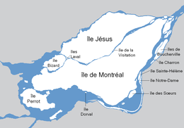
 Map of the Hochelaga Archipelago | |
 | |
| Geography | |
| Location | Saint Lawrence River |
| Coordinates | 45°32′58″N 73°39′02″W / 45.54944°N 73.65056°W |
| Total islands | 234 |
| Major islands | Île de Montréal, Île Jésus, Île Perrot, Île Bizard |
| Highest elevation | 234 m (768 ft) |
| Highest point | Mount Royal (Island of Montreal) |
| Administration | |
Canada | |
| Province | Quebec |
| City | Montreal |
| Additional information | |
| Discovered in 1535 by Jacques Cartier | |


The Hochelaga Archipelago (French: Archipel d'Hochelaga), also known as the Montreal Islands, is a group of islands at the confluence of the Saint Lawrence and Ottawa rivers in the southwestern part of the province of Quebec, Canada.
Previous Page Next Page


