Our website is made possible by displaying online advertisements to our visitors.
Please consider supporting us by disabling your ad blocker.
Fort Stanton
Fort Stanton | |
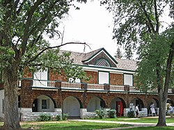
 Adjutant Office in 2009 | |
 | |
| Location | 7 mi. SE of Capitan near U.S. 380 |
|---|---|
| Nearest city | Capitan, New Mexico |
| Coordinates | 33°29′40″N 105°31′35″W / 33.49444°N 105.52639°W |
| Area | 195 acres (79 ha) |
| Built | 1855 |
| Architectural style | Colonial Revival, Mission/Spanish Revival |
| NRHP reference No. | 73001142 (original) 99001679 (increase) |
| NMSRCP No. | 60 |
| Significant dates | |
| Added to NRHP | April 13, 1973 |
| Boundary increase | January 14, 2000 |
| Designated NMHS | August 9, 2007[1] |
| Designated NMSRCP | May 23, 1969 |
Fort Stanton was a United States Army fort near Lincoln, New Mexico.
- ^ "Fort Stanton Historic Site History". New Mexico Department of Cultural Affairs. Archived from the original on December 22, 2016. Retrieved December 22, 2016.
Previous Page Next Page


