Our website is made possible by displaying online advertisements to our visitors.
Please consider supporting us by disabling your ad blocker.
Coon Rapids, Iowa
Coon Rapids, Iowa | |
|---|---|
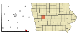
 Location of Coon Rapids, Iowa | |
| Coordinates: 41°52′30″N 94°40′43″W / 41.87500°N 94.67861°W | |
| Country | United States |
| State | Iowa |
| Counties | Carroll, Guthrie |
| Incorporated | November 2, 1882[1] |
| Area | |
| • Total | 1.78 sq mi (4.62 km2) |
| • Land | 1.78 sq mi (4.62 km2) |
| • Water | 0.00 sq mi (0.00 km2) |
| Elevation | 1,194 ft (364 m) |
| Population (2020) | |
| • Total | 1,300 |
| • Density | 729.11/sq mi (281.52/km2) |
| Time zone | UTC-6 (Central (CST)) |
| • Summer (DST) | UTC-5 (CDT) |
| ZIP code | 50058 |
| Area code | 712 |
| FIPS code | 19-16050 |
| GNIS feature ID | 2393629[3] |
| Website | www |

Coon Rapids is a city in Carroll and Guthrie counties in the U.S. state of Iowa. The population was 1,300 at the 2020 census, which is a decrease of 5 from the 2000 census.[4] The small portion of Coon Rapids that lies in Guthrie County is part of the Des Moines–West Des Moines Metropolitan Statistical Area.
- ^ "Coon Rapids-Iowa". City-Data. Retrieved March 19, 2011.
- ^ "2020 U.S. Gazetteer Files". United States Census Bureau. Retrieved March 16, 2022.
- ^ a b U.S. Geological Survey Geographic Names Information System: Coon Rapids, Iowa
- ^ "2020 Census State Redistricting Data". census.gov. United states Census Bureau. Retrieved August 12, 2021.
Previous Page Next Page


