Our website is made possible by displaying online advertisements to our visitors.
Please consider supporting us by disabling your ad blocker.
Camps Bay
Camps Bay
Kampsbaai | |
|---|---|
Suburb of Cape Town | |
|
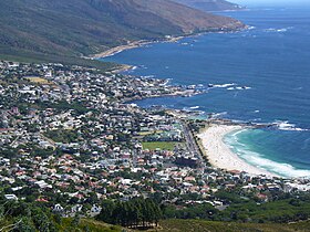
From top, a view of Camps Bay from Lion's Head. Camps Bay as seen from Table Mountain. | |
 Street map of Camps Bay | |
| Coordinates: 33°57′00″S 18°23′00″E / 33.95000°S 18.38333°E | |
| Country | |
| Province | |
| District | Atlantic Seaboard |
| Municipality | City of Cape Town |
| Main Place | Cape Town |
| Area | |
| • Total | 1.68 km2 (0.65 sq mi) |
| Population (2011)[1] | |
| • Total | 2,773 |
| • Density | 1,700/km2 (4,300/sq mi) |
| Racial makeup (2011) | |
| • Black African | 13.5% |
| • Coloured | 5.1% |
| • Indian/Asian | 1.7% |
| • White | 78.3% |
| • Other | 1.4% |
| First languages (2011) | |
| • English | 79.4% |
| • Afrikaans | 9.4% |
| • Xhosa | 2.1% |
| • Other | 9.0% |
| Time zone | UTC+2 (SAST) |
| Postal code (street) | 8005 |
| PO box | 8040 |
| Area code | 021 |
Camps Bay (Afrikaans: Kampsbaai) is an affluent suburb of Cape Town, South Africa, and the small bay on the west coast of the Cape Peninsula after which it is named. In summer it attracts many South African and foreign visitors.
- ^ a b c d "Sub Place Camps Bay". Census 2011.
Previous Page Next Page


