Our website is made possible by displaying online advertisements to our visitors.
Please consider supporting us by disabling your ad blocker.
Adour
| Adour | |
|---|---|
 Adour seen from the bridge at Aire-sur-l'Adour | |
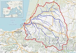
 Adour River watershed (Interactive map) | |
| Native name | L'Adour (French) |
| Location | |
| Country | France |
| Physical characteristics | |
| Source | |
| • location | High-Bigorre |
| • elevation | 2,200 m (7,200 ft) |
| Mouth | |
• location | Atlantic Ocean |
• coordinates | 43°31′46″N 1°31′25″W / 43.52944°N 1.52361°W |
| Length | 308 km (191 mi) |
| Basin size | 16,880 km2 (6,520 sq mi) |
| Discharge | |
| • average | 150 m3/s (5,300 cu ft/s) |
 | |
The Adour (French pronunciation: [aduʁ]; Basque: Aturri; Occitan: Ador) is a river in southwestern France. It rises in High-Bigorre (Pyrenees), in the commune of Aspin-Aure, and flows into the Atlantic Ocean (Bay of Biscay) near Bayonne. It is 308.3 kilometres (191.6 mi) long,[1] of which the uppermost ca. 11 kilometres (6.8 mi) is known as the Adour de Payolle. At its final stretch, i.e. on its way through Bayonne and a short extent upstream, the river draws the border between the Northern Basque Country and Landes regions.
Previous Page Next Page


