Our website is made possible by displaying online advertisements to our visitors.
Please consider supporting us by disabling your ad blocker.
Stattegg
Stattegg | |
|---|---|
 | |
 Location within Graz-Umgebung district | |
| Coordinates: 47°08′14″N 15°25′12″E / 47.13722°N 15.42000°E | |
| Country | Austria |
| State | Styria |
| District | Graz-Umgebung |
| Government | |
| • Mayor | Andreas Kahr-Walzl (ÖVP) |
| Area | |
| • Total | 25.85 km2 (9.98 sq mi) |
| Elevation | 432 m (1,417 ft) |
| Population (2018-01-01)[2] | |
| • Total | 2,927 |
| • Density | 110/km2 (290/sq mi) |
| Time zone | UTC+1 (CET) |
| • Summer (DST) | UTC+2 (CEST) |
| Postal code | 8046 |
| Area code | 0316 |
| Vehicle registration | GU |
| Website | www.stattegg. steiermark.at |
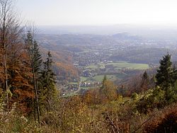
Stattegg is a Village and a suburb of Graz, the capital of the Austrian state of Styria. It lies at the bottom of the Schoeckl, a mountain of the European Alps. Stattegg has 2982 inhabitants (as of 1 January 2021) and consists of 13 Katastralgemeinden: Buch, Eichberg, Hochgreit, Hohenberg, Hub, Kalkleiten, Krail, Leber, Mühl, Neudorf, Rannach, Steingraben, Ursprung.
- ^ "Dauersiedlungsraum der Gemeinden Politischen Bezirke und Bundesländer - Gebietsstand 1.1.2018". Statistics Austria. Retrieved 10 March 2019.
- ^ "Einwohnerzahl 1.1.2018 nach Gemeinden mit Status, Gebietsstand 1.1.2018". Statistics Austria. Retrieved 9 March 2019.
Previous Page Next Page


