Our website is made possible by displaying online advertisements to our visitors.
Please consider supporting us by disabling your ad blocker.
Jarama
| Jarama | |
|---|---|
 Jarama River in Titulcia | |
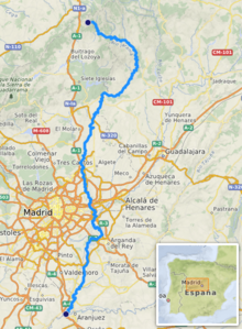
 Path of the Jarama | |
| Location | |
| Country | Spain |
| State | Guadalajara, Madrid |
| Region | Iberian Peninsula |
| Physical characteristics | |
| Source | Peña Cebollera |
| • location | Sierra de Ayllón |
| • coordinates | 41°9′58″N 3°32′18″W / 41.16611°N 3.53833°W |
| • elevation | 2,119 m (6,952 ft) |
| Mouth | Tagus |
• location | near Aranjuez |
• coordinates | 40°1′51″N 3°38′59″W / 40.03083°N 3.64972°W |
• elevation | 494 m (1,621 ft) |
| Length | 194 km (121 mi) |
| Basin size | 5,047 km2 (1,949 sq mi) |
| Discharge | |
| • average | 31.7 m3/s (1,120 cu ft/s) |
| Basin features | |
| Progression | Tagus→ Atlantic Ocean |
| River system | Tagus |
| Tributaries | |
| • left | Henares, Tajuña |
| • right | Lozoya, Guadalix, Manzanares |
| Tagus Basin | |
Jarama (Spanish pronunciation: [xaˈɾama]) is a river in central Spain. It flows north to south and passes east of Madrid where the El Atazar Dam is built on a tributary, the Lozoya River. It flows into the river Tagus in Aranjuez. The Manzanares is a tributary of the Jarama.
Previous Page Next Page


